GHANA
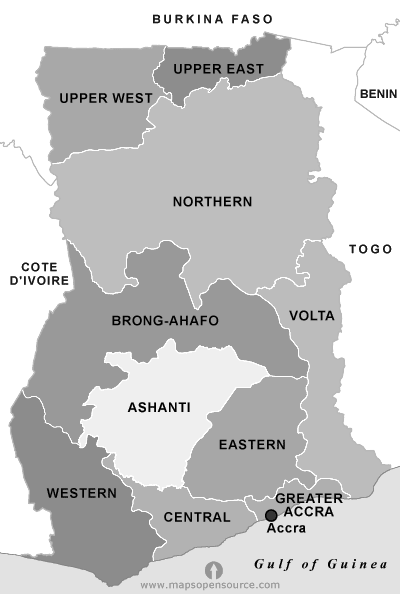
Ghana, is a west African country, bounded on the north by Burkina Faso, on the east by Togo, on the south by the Atlantic Ocean,and on the west by Cote d'Ivoire.
Formerly a British colony known as the Gold Coast, was led to independence by Dr. Kwame Nkrumah on the 6th of March, 1957.
Ghana became the first black nation in sub-Saharan Africa to achieve independence from colonial rule.
The country is named after the ancient empire of Ghana, from which the ancestors of the inhabitants of the present country are thought to have migrated.
Ghana's Political History from 1957
Political Highlights
- 1957 - independence, Nkrumah of CPP is PM
- 1960 - declared republic, one party system, presidential system
- 1966 - military overthrow of 1st republic
- 1969 - 2nd republic, Busia of PP is PM
- 1972 - military overthrow of 2nd republic
- 1978 - palace coup to restructure military government
- 1979 - junior officer uprising and military housecleaning
- 1979 - ushered third republic, Limann of PNP is President
- 1981 - overthrow of the constitutional PNP gov't by the PNDC military junta
- 1983 - Attempted overthrow of the PNDC junta by other junior army men
- 1992 - Rawlings of NDC is Dem elected as President
- 1996 - Rawlings of NDC is re-elected
- 2001 - Kuffour (NPP) is President
- 2005 - Kufuor begins second-term in office
- 2009 - John Evans Atta Mills (NDC) is President
- 2012 - John Dramani Mahama (NDC) is sworn in as President following death of President Mills
- 2013 - John Dramani Mahama (NDC) is sworn in as President after winning the 2012 general elections
- 2017 - Nana Addo Dankwa Akufo-Addo(NPP) is sworn in as President after winning the 2016 general elections
Ghana General Information
Area Size Of Ghana
238,537 sq km (92,100 sq miles)
Population (Provisional Results)
24,233,431 (2010)
Male: 11,801,661 (48.7%)
Female: 12,421,770 (51.3)
Average Population Density
55.5 per sq km
Capital
Accra (3,909,764 representing 16.1 percent of the population)
International Airport
KOTOKA International Airport
Time
Greenwich Mean Time (GMT) is used in Ghana - e.g. Tokyo +9 hours.
Language
The official language is English. Local Ghanaian languages are widely spoken, including Twi, Fante, Dagbani, Ga and Ewe.
Currency
Bank of Ghana
Religion
Ghana is a secular States. Freedom of religion is permitted enshrined in the Constitution of Ghana
Independence
March 6, 1957
Creation of Republic
July 1, 1960
Currency Exchange
The Ghanaian Cedi is pegged to the US Dollar. The exchange rate system has been liberalised and foreign currency is freely available through authorised dealers including banks and forex bureaux.
Credit Cards
Credit Cards are accepted by leading hotels, restaurants, banks and businesses. The most widely accepted credit cards are American Express, Diners, MasterCard and Visa.
Travellers Cheques
All banks and forex bureaux accept Travellers' Cheques.
Geography
Ghana is situated in West Africa and is a rectangular-shaped country bounded to the north by Burkina Faso, the east by Togo, the south by the Atlantic Ocean and the west by Cote d' Ivoire. A narrow grassy plain stretches inland from the coast, widening in the east, while the south and west are covered by dense rainforest. To the north are forested hills beyond which is dry savannah and open woodland. In the far north is a plateau averaging 500m (1600ft) in height. In the east the Akuapim Togo hills run inland from the coast along the Togo border. The Black and White Volta rivers enter Ghana from Burkina Faso merging into the largest man-made lake in the world, Lake Volta. Ghana's coastline is dotted with sandy palm-fringed beaches and lagoons.
Climate
Ghana has a tropical climate, characterized most of the year by moderate temperatures (generally 21-32°C (70-90°F), constant breezes and sunshine. There are 2 rainy seasons, from March to July and from September to October, separated by a short dry season in August and a relatively long dry season in the south from mid-October to March. Annual rainfall in the south averages 2,030mm but varies greatly throughout the country, with the heaviest rainfall in the Western Region and the lowest in the northern Regions.
Required Clothing: Tropical lightweight clothing. Sunglasses can be useful.
Education
There are numerous grammar, secondary, basic, commercial, technical and vocational educational institutions throughout the country as well as universities, numerous specialized tertiary institution, and a functional literacy programme targeting illiterate adults. Ghana is the Headquarters of the West African Examinations Council, which conducts examinations for most of the institutions in the first and second cycles.
Electricity
Electricity in Ghana is 220-240 volts AC, 50Hz; usually 3-pin plugs. Single phase, 3-pin plugs are used in larger buildings. Older buildings have 2-pin plugs. Light bulbs are of the bayonet type. Electricity fluctuates noticeably and an Uninterruptible Power Supply (UPS) is recommended for sensitive electrical equipment, especially computers and printers (although for printers it may be more practical to have a line conditioner). When you purchase a UPS, be sure that it is intended for 50-60mhz. This is particularly true if you plan to run your 100-110volts computer off a transformer. Transformers do not covert cycles, only voltage. Before you plug your expensive UPS into an electrical outlet in Ghana, ensure that the polarity of the outlet or transformer is correct. An incorrectly wired outlet - a common occurrence - will destroy your UPS almost immediately. You can check your outlets with a voltage meter, or have an electrician check all outlets for you.
Communications
Telephone: IDD service is available in most parts of the country.
Country Code: 233.
Outgoing International Code: 001 - International calls can be made by buying a phone card or using a communication center which has an international direct dialing service.
Mobile Phones: Mobile phones are widely used. You can buy your own handset or get if from authorised dealers like Mobitel, CellTel, or Spacefon etc.
Fax: There is a 24-hour fax service throughout the country.
Telegram: Services are available from Post Offices throughout the country.
Internet: Internet Providers and Internet Cafes are available throughout the country.
Post: Airmail letters, EMS, DHL and other expedited mail services are available.
Press: Daily/Weekly newspapers are in English and include The Ghanaian Times, Daily Graphic, Business Weekly, The Mirror, Weekly Spectator, The Pioneer, Chronicle, Statesman, The Democrat, Free Press etc.
Ghana Coat of Arms
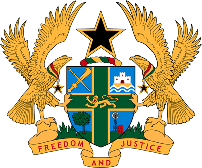
Composition
The Ghana Coat of Arms is composed of a shield, divided into four quarters by a green St. George's Cross, rimmed with gold. The following are the symbols in the quarters and their meanings.
- Crossed linguist staff and ceremonial sword on a blue background
Position: Top left-hand quarter. Represents local administration - A heraldic castle on a heraldic sea with a light blue background
Position: Top right-hand quarter. Represents National Government - A Cocoa Tree
Position: Bottom left hand quarter. Represents the Agricultural wealth of the country - A Mine Shaft
Position: Bottom right hand quarter. Represents the mineral wealth of the country - A Gold Lion
Position: In the centre of the green St. George's Cross. Represents the continued link between Ghana and the Commonwealth - Black five pointed star rimmed with gold standing on the wreath of red, gold and green colours
Position: Surmounting (On top of) the shield. Represents the lodestar of African Freedom - Two Eagles, around each of whose neck hangs a black star suspended from a ribbon of Ghana colours - red, gold and green
Position: Supporting the shield (Coat of Arms). Signifies a protector with strength, very clear and attentive eyes keeping watch over the country - The motto Freedom and Justice is found under the shield.
The Ghana National Flag
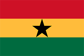
The Ghana National Flag was designed by Mrs. T. S Okoh, a Ghanaian, to replace the flag of the United Kingdom upon the attainment of independence in 1957.The flag of Ghana consists of the colours red, gold and green in horizontal stripes with a five pointed black star in the centre of the gold stripe.
Red represents the blood of those who died in the country's struggle for independence.
Gold represents the mineral wealth of the country.
Green symbolises the country's rich forests.
The Black Star stands for the lodestar of African Freedom.
God bless our homeland Ghana,
And make our nation great and strong,
Bold to defend for ever,
The cause of Freedom and of Right.
Fill our hearts with true humility
Make us cherish fearless honesty,
And help us to resist oppressor's rule
With all our will and might for evermore.
Hail to thy name, O Ghana,
To thee we make our solemn vow:
Steadfast to build together
A nation strong in Unity;
With our gifts of mind and strength of arm,
Whether night or day, in mist or storm,
In every need what'er the call may be,
To serve thee, Ghana, now and evermore.
Raise high the flag of Ghana
And one with Africa advance;
Black star of hope and honour,
To all who thirst for liberty;
Where the banner of Ghana freely flies,
May the way of freedom truly lie
Arise, arise, O sons of Ghanaland,
And under God march on for evermore.
Raise high the flag of Ghana
And one with Africa advance;
Black star of hope and honour,
To all who thirst for liberty;
Where the banner of Ghana freely flies,
May the way of freedom truly lie
Arise, arise, O sons of Ghanaland,
And under God march on for evermore.
National Pledge
I promise on my honour to be faithful and loyal to Ghana my Motherland.
I pledge myself to the service of Ghana, with all my strength and with all my heart.
I promise to hold in high esteem our heritage, won for us through the blood and toil of our fathers; and I pledge myself in all things to uphold and defend the good name of Ghana.
So help me God.
The centuries-old traditions of the people of Ghana and the diversity of the distinct ethnic groups have created a rich culture that is the splendid legacy of modern Ghana.
To the people of Ghana, the traditions of their ancestors are still an important part of daily life. Customary leaders have historical authority over tribal and family matters, and customary lands are an important heritage.
Important events in life are marked by special rites and rituals. Child naming, puberty initiations, marriage and death are marked by family ceremonies, while seasonal festivals bring a whole people or clan together in spectacular fashion.
A common feature is the belief in the Supreme Being, in life after death and in the nearness of dead ancestors. Festivals also recall past events, and consecrate a new season with confidence and hope.
Traditional fetish shrines, sometimes concealed but more often displayed, are important centres of worship and traditional healing, and an influential part of traditional life.
Of special significance are the Posuban shrines, particular to the Fante communities in Southern Ghana. Fanciful buildings lavishly decorated with folk art, they are religious centres for Fante warrior organisations.
Many festivals include thrilling durbars of chiefs, when tribal leaders and Queen Mothers process in decorated palanquins, shaded by traditional umbrellas, and supported by drummers and warrior discharging ancient muskets.
In Ashanti, the Adae and Akwasidae festivals vividly bring the splendour of the Asante kingdom to life, when the Ashantehene (King), adorned in all his gold regalia, comes out to receive the homage of his people. The Asantehenes dancers, praise-singers and horn-blowers surround the King and his procession, in a never-to-be-forgotten spectacle. The dates of many festivals are determined by traditional calendars, often decided close to the event.
Major Festivals
| Festival | Month | Town & Region |
| Edina Buronya | New Year | Elmina, Central |
| Adae and Akwasidae | Every six weeks throughout the year | Kumasi, Ashanti |
| Ngmayen | March/April | Odumase, Eastern |
| Gologo | March | Upper East |
| Dipo | May | Krobo Odumasi, Eastern |
| Aboakyer | May | Winneba, Central |
| Bakatue | July | Elmina, Central |
| Asafotufiam | July/August | Ada |
| Odambea | August | Saltpond, Central |
| Damba | August | Upper West |
| Kumdum | August/November | Western |
| Homowo | August/September | Accra |
| Fetu Afahye | September | Cape Coast, Central |
| Kobine | September | Upper West |
| Odwira | September/October | Akropong, Aburi Eastern |
| Hogbetsotso | November | Anloga, Volta |
Public Holidays
| Date | Holiday | Ghana | Australia |
|---|---|---|---|
| 1st January | New Years Day | ||
| 7th January | Constitution Day | ||
| 6th March | Independence Day | ||
| 13th March | Canberra Day | ||
| 22nd March | Human Rights Day | ||
| 7th April | Good Friday | ||
| 8th April | Easter Saturday | ||
| 9th April | Easter Sunday | ||
| 10th April | Easter Monday | ||
| 25th April | ANZAC Day | ||
| 1st May | International Workers Day | ||
| Eid Ul-Fitr | |||
| 25th May | African Unity Day | ||
| 29th May | Reconciliation Day | ||
| 12th June | Sovereign's Birthday | ||
| 16th June | Youth Day | ||
| Eid Al-Adha | |||
| 4th August | Founders Day | ||
| 2nd October | Labour Day | ||
| 21st September | Kwame Nkrumah Memorial Day | ||
| 1st December | Farmers Day | ||
| 25th December | Christmas Day | ||
| 26th December | Boxing Day |
Coming soon......
School going age in Ghana is from age 3-21. The educational structure of Ghana comprises:
- Pre-School (Ages 3-5)
- Basic/Primary School equivalent to Elementary School (Ages 6-11)
- Junior High School equivalent to Middile School (Ages 12-14)
- Senior High School equivalent to High School (Ages 15-17)
- Tertiary Education/Institution equivalent to College/ University (Ages 18-21)
Under the tertiary institutions we have the Polytechnics and the Universities. One has the option after completion of a High School to enter into a Polytechnic or the University.
There are also Vocational and Teacher Training Intitutions in Ghana.
Ghana Education Service
Login on to http://www.ghana.gov.gh
Schools & Universities
There are several Government and Private Universities, University Colleges and Professional Institutions in Ghana.
Government Universities
- University of Ghana, Legon
- Kwame Nkrumah University of Science and Technology, Kumasi
- University of Cape Coast, Cape Coast
- University Of Education, Winneba
- University of Development Studies, Tamale
- Universities of Mines and Technology, Tarkwa
- University of Health and Allied Sciences, Ho
- University of Energy and National Resources, Sunyani
Some Private Universities (Affiliated to Major Ones)
- Valley View University, Accra
- Central University College, Accra
- Ashesi University, Accra
- University College of Agriculture and Environmental Studies, Bunso
- Regent University College of Science and Technology, Accra
- Methodist University College of Ghana, Dansoman, Accra
- Islamic University of Ghana, East Legon, Accra
- Presbyterian University, Kwahu
- Catholic University, Fiapre Sunyani
- Ghana Telecom University College, Accra
- Evangelical Presbyterian University, Ho
- Pentecost University College, Sowutuom, Accra
- Ghana Armed Forces Command and Staff College-Masters Degree